Monday 4 July 2011

WEDNESDAY, JUNE 29, 2011
Maryhill, Washington to Reno, Nevada


Ah yes, leaving in the morning. A little adventure all in itself. We were packed up and had pulled out of the campsite about 6:30 AM. I really didn’t care if we woke anyone up, started my bike and putted out. I think Al tried to be a little more considerate and pushed his bike away from the site a bit before deciding to start it up. Anyway, we both got going and made our way down the access road to the entrance.  However, when we got there the gates were closed and locked!  What the F...?  We can’t leave until a ranger comes to work?  We had already been down to the other end of the camp and knew there was no exit down there. It was exit this gate or wait until somebody arrived to open it.
There was a space of about three feet at the end of the gate that I figured I could ride through, so wasting no time I drove through it and was out on the road next to the highway in a few seconds. Al was reluctant to ride through that space since his bike was lower than mine and weighed a lot more. Plus, there was no path, it was just a way through some tall grass over rough ground. You couldn’t see precisely what was under that grass, but I knew there was at least one large rock that I had not hit. Another consideration was the side bags. You have to take them into account too when negotiating tight spaces. 
The ground was a bit rough, but since it had posed no problem for the V-Strom I first told Al to just drive on through the same way I had.  I drew an imaginary line over the ground to indicate where he should steer the front wheel.  When that didn’t immediately appeal to him, I suggested that maybe a dirt road we could see from there went around behind some bushes we could also see and came out on the other side of the gate.  It seemed plausible from our viewpoint. Al drove down there and checked it out. Nope, no way out except through or around the gate the way I had gone. He decided to try it.  
I positioned myself on his right side in case he lost his footing and his bike started to fall that way while he made his way slowly over the rough ground. I suggested he give it some extra power, however,  to be sure the bike would make it over the uneven spot. He went in and did not fall one way or the other.  The front wheel went through the space and over the hump of grass-covered earth, but when his rear wheel went down in the depression in the ground the FJR high-centered on the hump and the rear wheel couldn’t get any more traction. Al spun the rear wheel some, but nothing happened. The bike was stuck. This seemed impossible. How could a motorcycle get stuck? Al’s bike weighs 650lbs, and since it was high-centered and the kickstand couldn’t be deployed, he couldn’t dismount the bike either. I got down on my hands and knees to see what I could see, and what I saw was that the underside of his engine area, frame and exhaust pipes had been driven into the soil and the bike was basically resting on that point. This made it impossible to go forward and also had the effect that when he spun his rear wheel it dug the hole deeper and deeper.  I saw that at least one of two things had to be done for him to be able to get any more forward movement. One, raise the ground under his rear wheel and/or two, dig the ground out from under and in front of where his bike was high-centered.
First, we tried pushing his bike backwards out of the hole. I pushed from the front and Al dug in with his feet pushing backwards. We tried several times, but to no avail. The bike was not going backwards either. I went running around the area looking for a board to jam down in front of the back tire to give it something to get traction on. No boards. Next, I went looking for flat rocks and found some.  I jammed them in between the back tire and the side of the hole the bike was in. Al tried going forward, but the stones were not enough. He was still high-centered and that was what was impeding forward movement. The ground had to be dug out from beneath the bike. Not only beneath it, but also somewhat in front of the point where it was stuck so it could get at least a few inches of unimpeded forward movement.
About this time, a park employee arrived. Not a ranger, some civilian. He came over to see what was going on. I told him we could use some help trying to push the bike out of the hole. Nope, he had a bad back, he said.  To me he looked like an alcoholic loser, anyway, who had come to work late, so I put him out of my mind. In the meantime he opened the gate. Shit, if we had left just 30 minutes later, we wouldn’t have had this problem. Well, we had it and nothing could change that.  I dug with a sense of urgency. Why exactly, I don’t know, but I felt it had to get done as soon as possible. Maybe I was thinking the real ranger would come and give us some grief over having gone around the gate. He’d never know about it if we could get out now. I was pretty sure since the guy had come to work late, he wasn’t going to bring the incident to the attention of anyone because that would highlight the fact he hadn’t opened the gates on time.
I clawed at the ground with my bare fingers. Luckily it was pretty soft ground. It came away with some effort, broken fingernails and skin, but it came. I kept it up, going from one side of the bike to the other until I could see light beneath it. I didn’t want to stop too soon just to have it lodge again because I hadn’t taken out enough dirt, so I dug for a while longer until it looked like it might be enough. In the process, I burned the backs of my hands several times on the hot exhaust pipes. This created another fear that they might start a grass fire. I hurried. I finished digging and drove the flat stones in under the rear wheel again and got behind the bike to give it a shove. Al fired it up and put it in gear. The bike gave a lurch and like magic was over the hump and out of there. It was suddenly like there hadn’t even been a problem. We were free to go.


Maryhill, Oregon

We intended to eat breakfast at Linda’s, but now my appetite wasn’t that great. Nevertheless, it seemed the best thing to do was to go to breakfast, which we did, and then we hit the road, going south on the 97 through Oregon. We took no more pictures and just drove south through Wasco, Moro, Grass Valley, Kent, Shaniko until we got to Madras, where we had originally planned to overnight instead of in Maryhill. We refuled in Madras where we met a BMW driver from Portland who was headed to Nebraska via the 20 and 26, he said. 

Al noted that if we passed through Sisters, he wanted to stop and go to a quilting store there to get something for Susan, but Sisters was 20 miles east of our road. We went on through Bend to La Pine, where we stopped and had lunch. Not long after we pulled back out onto the highway a sign suddenly appeared that said RENO and indicating the way was left onto Rt. 31.  I pulled over, checked the atlas and decided this was probably the best way for me to return home instead of going on down the 97 to Klamath Falls, which was where we had decided we would split up. Al and I said our brief good-byes, wished each other a good trip and parted ways.
The rest of my trip was pleasant. The 31 went through high country along the edge of the Deschutes National Forest and alongside Summer Lake. I stopped in Paisley for fuel. North of Paisley I photographed dust rising from the alkali flats. After Paisley there was a beautiful scene of the green valley, the barren hills and the roadside flowers. I took no more pics during the trip. In Alturas, CA, I refueled and drove straight through to Reno arriving before the sun set.  When I called Al in Weed, CA, next morning to inform him I was home, he couldn’t believe I had made it home that fast. It hadn’t been that fast. I pretty much drove the speed limit. I just kept at it. There was nobody to talk to, no reason to stop, and once I realized I could be home the same day that became my intent.  Al said he was heading on down the I-5 and figured he had another overnight somewhere before arriving home.

Alkali Flats, with Dust Rising

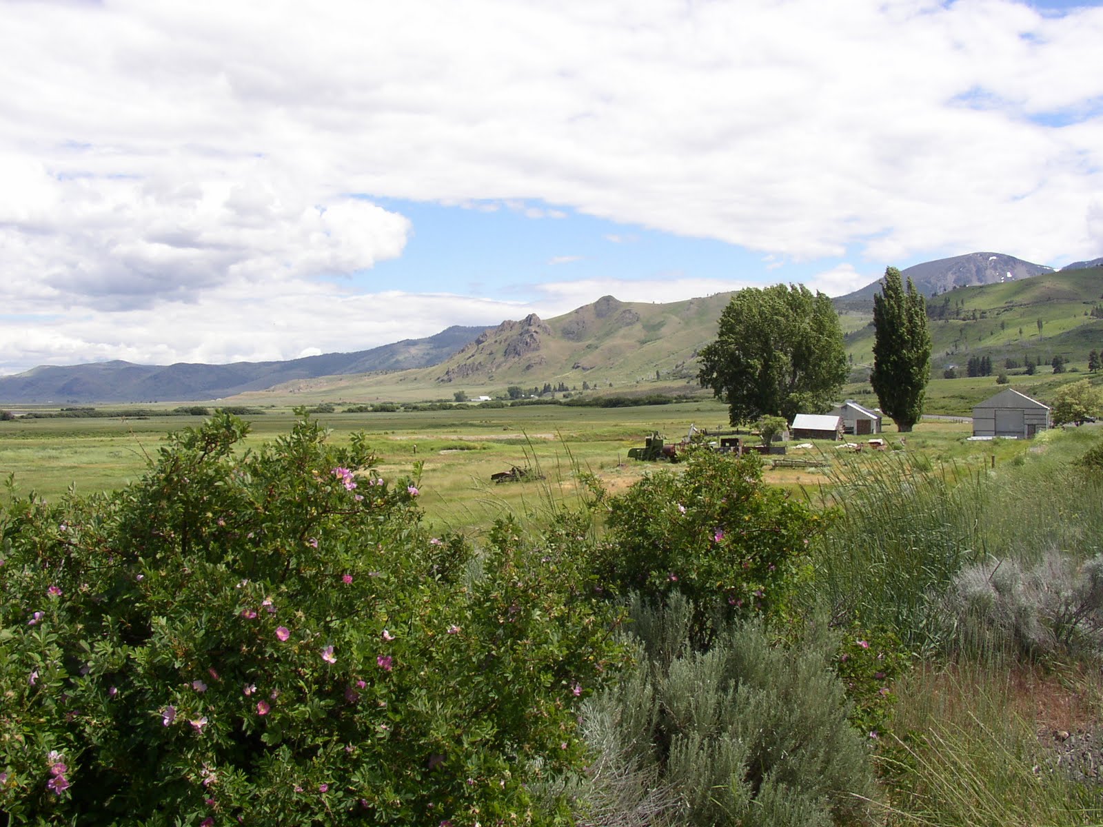
Barren Hills and Roadside Flowers
Next morning, life had returned to  normal for me. I had an overgrown lawn to mow, dead branches to cut from some junipers, spider mites to wash out of the junipers using my power washer, some Hollyhocks and daisies to plant and a dead rose bush to uproot. I also washed my motorcycle, my truck and my wife’s car, then took the Suzuki for a servicing. I had driven 3003.8 miles on the trip with Al and Joe. The bike had gone over 15,000 miles. I had stopped 22 times for gas, consuming 59.712 gallons at a cost of $230.04. My milage had averaged a tad over 50 mpg.  Not bad.

Tom at Home in Reno, Nevada, 
Back to the List


TUESDAY, JUNE 28, 2011
Tacoma, Washington to Maryhill, Washington


Next morning we all arose early and Mike very considerately escorted us to a restaurant for breakfast that was located right on Rt. 7.  After a good breakfast, all we had to do was start riding south.  A quick good-bye and we departed and down 7 in good spirits.  The route was kind of citified at first, but then became rural and beautiful. Somewhere on the road before Elbe, we saw Mt. Rainier, the highest mountain in Washington state and in the Cascades off to our east and partly obscured by clouds.      


Mt. Rainer


When we arrived in Elbe, logging trucks were being unloaded by this machine that could lift the entire load of logs off the truck at once. Having been around logging operations quite a bit as a child, I recalled how in those days they had to just let the logs roll off the truck onto the ground and handle them basically one at a time after that.  We also gassed up in Elbe, and while standing at the pump, I happened to look up and saw a car stopped waiting for a mother duck to cross the road followed by 6 or 7 ducklings all in single file – a very orderly and impressive procession. Missed the photo op, though.


Al, with Logging Truck
We only stopped one more time on Route 101 south, at a small store with no restroom, but did offer a port-a-potty outside.  Al may have a thing for port-a-potties, since I recall he posed for a picture up in Idaho next to one.  No photo this time, however, but take my word for it, Al was impressed and even complimented me on my “good eye” for pointing it out to him.

Moving right along, now...We reached Morton on the 7, turned east on the 12 and found Randle and the 135.  Parked next to the restaurant located on the intersection of the 135 and 12, where we would go up into the Cascades again, we rechecked the map.  A waitress on break from the restaurant asked us about our travels and opined that the side road up to Mt. St. Helens might not be open yet.  As we got ready to leave she invited us to come back by for a cup of coffee.  However, our intention was to continue south through the mountains to the Oregon state line and not return to Randle.  
The 135 is a beautiful road and we were both impressed with the forest. At one point we stopped at an abandoned park facility where the overgrowth was impressive. It had that deep, dark forest kind of feeling. Although the white lines were still visible on the abandoned parking lot and some signs were still in place indicating the park facility had been in use probably not all that long ago, the forest had retaken much of it. It was a small mystery why it had been relegated to disuse. Nearby, there were some berries ripening on a bush that resembled blackberries in shape but in their unripened state (I tested a couple) were salmon pink in color. The aforementioned waitress later told us (foreshadowing) they were probably salmonberries, which a quick Internet search has just verified was indeed the case. We noted Mt. Rainier again in the east.


Route 135

That Deep, Dark Forest Kind of a Feeling

Al, with Mt. Rainer in the Distance

Now we ascended the road into the hills. The road was narrow, in disrepair in many places and curvy. Except for the potholes and bumps it was a nice motorcycling road.  I even enjoyed negotiating the bad spots.  At one curve we came upon what I took to be a forest service vehicle parked on the side of the road with its emergency flashers going.  I didn’t see a ranger, but as we went by noticed an odd scene.  My momentary impression was that of a young, bearded man, possibly wrapped in a blanket or wearing a heavy coat of some kind standing on the other side of the vehicle next to a bulk lying on the ground.  When we stopped later I asked Al if he had noticed what was going on back at the scene and that it seemed “odd” to me.  The guy seemed out of place and I thought since we hadn’t seen the officer that maybe the bulk on the ground was the fresh murder victim of the stranger next to the car.  However, that concern was not enough to cause us to go back down the hill and check it out.
We continued up the hill until we came to the sign for the turn off to Mt. St. Helens.  I took the right and suddenly spied the “Road Closed” sign directly in front of me.  I turned around and remarked to Al, “Well, that settles that, the road’s closed.”  I figured it was no big loss, we’d just continue along the 135 through the mountains. But Al exclaimed, “And the other one’s closed too!”. What the F..., closed?  And sure enough, it was.  I hadn’t noticed it myself as we came up the hill, but Al had.  Both roads were blocked at this point.  


"What the F..., Closed?"

"And the Other One's Closed Too!"


There was no explanation why.  No snow or rockslides were apparent, but we had no choice but to return to Randle.   Somewhat dispirited by this, Al pretty much decided we’d take the 12 east to Yakima and continue on the 97 south, basically heading to our respective homes.  I didn’t object.  We were both kind of tired at this point anyway, and without the prospect of riding through beautiful mountain country now, were more or less disposed to wrapping up the ride.  Al was already envisioning connecting with the I-5 again and calculated he’d need to spend a couple of more nights on the road before getting home.
Returning down the hill to Randle, we came upon the scene of a tow-truck having just winched a car up the hill from where it had apparently run off the road.  I didn’t recognize it as the same point where we had noted the official car earlier, but Al did, as he later told me.  I thought the accident had occurred while we had been up the hill discovering the roads were blocked.  But not...the young man I had noted earlier had apparently run his car off the road and the officer had been down at the bottom inspecting the wreckage as we had driven by.  No wonder I thought the guy had had a strange demeanor.  He was probably in shock from the accident that had happened just prior to our arrival.
Back down the hill, we decided to go into the restaurant.  On the way in I noticed the pie case.  At the table I noticed the menu offered fresh-made cinnamon rolls.  After having passed up a few opportunities for cinnamon rolls (particularly at Minnie’s in Thompson Falls), I resolved now would be the time to get ‘er done. And so it was.  While Al had a regular meal of some kind, I enjoyed a cup of soup and a cinnamon roll with coffee.  The last two or three days I had been suffering from drowsiness while riding.  On a couple of occasions I had actually nodded off.  You wouldn’t think it would be possible on a motorcycle, but it is.  I had been drinking a lot of coffee to stay awake on.  

Anyway, having brought the road atlas into the restaurant, we verified the way we’d take now.  Vexed about the closed roads, Al wondered why the waitress hadn’t mentioned the road was closed before we went up.  My guess is, she just didn’t know.  Now she did know as we filled her in and she could advise other riders intending to take the 135.  Sitting there, we observed the aforementioned wrecker pull the disabled vehicle into a service station across the street.  On the way down the hill we had seen other cyclists headed up but we didn’t know any hand signals for “the road is closed ahead” and just had to watch them race by enjoying the road for now.  We did meet a motorcycling couple in the restaurant who, if not glad the road was closed, at least learned they couldn’t get through the mountains that way.
Now we set off on the 12 east toward Yakima and crossed the White Pass through the Cascades for our last time in the mountains. On the way we had to stop for construction. While stopped another biker came up behind us.  He was taking the relatively short ride from Packwood (a small town on the 12 we had just come through) to Yakima.  Once the traffic started moving again, he passed us on an open stretch.  
Once we made Yakima and connected with the 97 south, the ride was pretty uneventful.  We gassed up in Wapato.  A fireworks stand was in operation nearby, and someone kept lighting off firecrackers to attract the customers.  I said the ride was uneventful travelling down the 97, but after driving through some impressive rock formations, probably in the Dry Creek area, the country opened up and there were beautiful vistas of mountains and farmland.


Rock Formations, Dry Creek

Beautiful Vistas


 As we approached the Columbia River at Maryhill, we came upon giant fields of probably hundreds of wind turbines in the hills. You don’t realize how huge these things are until you come to within a few hundred feet of one. They tower many stories high and their bases and blades are huge. They have a graceful appearance with their gigantic blades turning slowly around.  They continued until we finally arrived at the Columbia River at Maryhill, WA, where there was an attractive campground with lots of grass. 


Evening in Maryhill, Oregon
It was an inviting scene as we came down the hill toward the river and I pulled over and suggested to Al that we stop there instead of going on down the highway to Madras, OR, where we knew there was a KOA.  He agreed.  We pulled into the camp to register and the ranger told us there were grassy tent spaces.  He gave us a list of available sites to check out, told us to go on in, pick one and come back and let him know which one we had chosen, and to pay, of course. We drove in and it was all very attractive and cool looking.  However, on the way in I noticed signs that said you couldn’t put tents on the grass, that it was all scheduled for watering. And indeed, there were sprinklers going all over the park. Tents had to be set up on the gravel!  Well, by this time, we had more or less committed and it was a long way to the KOA in Madras, so we just noted that the gravel here was finer than it had been in Winthrop, WA, and wouldn’t be so bad.   Al started setting up his stuff and I went back to pay the ranger.  
Settled in and looking around, we noted we could still see the blades of some of the wind turbines turning over the tops of the ridges across the highway. The Columbia was 200 ft. away and was impressively wide. The only waterway that I had seen that was wider was the St. Lawrence Seaway in Canada. I had crossed the Mississippi at least four times, but couldn’t remember any of those crossings. Maybe they had been at night. Anyway, we took a short exploratory walk along the river, took some shots of the landforms  and then decided to cross the bridge across the Columbia to Biggs, OR, where the ranger had mentioned there was a restaurant called Linda’s.


Biggs consists of a McDonalds, a filling station, one or two other fast-food places and Linda’s combination convenience store and restaurant on the Oregon side of the Columbia river. It was a good thing we decided to ride over from the campground because there was no place for pedestrians on the bridge. From the bridge we saw a barge and a couple of other watercraft on the river. I wondered just how navigable it was. 
The menu at Linda’s was not memorable.  Can’t recall a thing from it. Don’t even know what we ordered.  While we were sitting there, however, we chatted about the trip and this and that. I recalled that there used to be a chewing gum that contained caffeine that drivers could use to stay awake.  I wished for some of that because of my bouts of drowsiness while riding but hadn’t heard of it for a long, long time.  I also recalled a product called “No Doze”, but couldn’t remember if it was the same as the chewing gum I was thinking of.
Looking out the window I noticed  a motorcyclist in leathers standing next to his sport-touring bike that had two big square side cases on it. Then a car with New Jersey plates parked in front of Linda’s. The driver, a man, had long brown hair that was braided into a single pigtail that hung down the middle of his back. I thought it looked kind of odd. His wife, I could see from my vantage point, was quite the lady, maybe the 300 lb variety, lots of big, black-dyed hair with a big red rose pinned in it. The man’s clothing was normal, but when the lady got out of the car I saw she was extremely colorfully attired, her blouse was cut pretty low and her makeup was heavy, lips painted dark red. Not wanting them to catch me staring at them I turned my head away noticing no more details but thought “circus act”. They entered the restaurant behind be. Now Al got his first look at the couple, but didn’t reveal anything through his facial expression until they had passed behind him and taken a booth. I hadn’t paid particular attention to them when they entered since their backs were mostly to me.  Al looked at me and rolled his eyes while giving a little jerk of his head in their direction. Had I gotten a load of that? He said he had gotten the full frontal view of the woman and her entire amply visible bodice was covered with tatoos. I regretted I had missed that particular detail, but it went with my thought about them maybe working in a carnival. The fattest tatooed lady and her pigtailed, probably knife-throwing husband. We decided not to take pictures. Proof, however, that you see all kinds on the road.
Since I had paid $22 for our campsite, Al gave me $10 to help pay the check. What a good guy he is. I scanned the chewing gum display on the way out to see if they had that caffeinated one.  Nope. I paid the check and went outside where I struck up a conversation with the aforementioned rider, who was riding a V-Strom 650cc, as it turned out. He had been over in eastern Washington where he said he liked to go riding and was headed for Portland where he wanted to be that night. He had had something called a Power Master, or Power Controller, or the like mounted on his bike. It’s function was to use a microcomputer to somehow monitor the engine’s performance and utilize it more efficiently and smoothly. He reported he had noted some improvement in performance. He didn’t really understand the device and had just let his mechanic install it for experimental purposes. I didn’t quite see the value of it either.  

Anyway, as we were discussing the merits of the 650cc versus the 1000 (my version of the V-strom) and had both admitted to dropping the bikes several times when we had first gotten them (probably due to the height of the bike), Al came out of Linda’s and handed me a pack of “No Doze” in tablet form. Pretty nice of you, Al, thanks.  At this point, we all saddled up and departed for our respective destinations.
Back at the camp, Al and I took a walk around before it got dark, took a couple of pics, but didn’t take showers that night. They had pay showers that cost 50 cents for three minutes! Not such a great place after all, gravel to sleep on and pay showers, bummer! The toilets were free, at least. We noticed that two female bicyclists, who had started setting up camp right next to us before we went to dinner had now moved to another part of the camp. We wondered if they had taken offense at the motorcycles and maybe didn’t want to be woken up by our leaving in the morning.
MONDAY, JUNE 27, 2011
Vancouver, BC to Tacoma, Washington


Joe arose early the next morning, now in coat and tie and ready to go back to work.  Rachel, also up early, took care of me and Al  as we prepared to depart, even gifting us with our own individual bags of cookies to take along with us (they saw good service). Finally, seeing us packed up and ready to go, she bade us farewell, and off we went after having studied the detailed instructions Joe had drawn up for us to get us out of the city and on our way south to the USA checkpoint.
After a bit of confusion about exactly where Route 99 was at one point, Al and I made our way out of Vancouver and to the “Peace Arch” USA border checkpoint fairly uneventfully.  However, once there, we encountered more intense stop-and-go traffic. This time I resorted to turning my engine off at every stop to avoid the kind of overheating that had killed my motorcycle in Vancouver.  

After a bit of jockeying around, Al and I got into the same line for checking through into the USA. While waiting, I noted that those folks who got orange stickers placed on their windshields by the border patrol agent had to take a left into no-man’s land instead of proceeding into the USA.  Poor suckers, I thought.  Finally, I was up to the cameras and other unidentifiable detection devices mounted at the waiting line.  I smiled sarcastically at the camera in my best Erich Honecker style.  I was called forward by the officer.  He asked a couple of non-threatening questions, then informed me that he was sorry but the computer had randomly decided to pick me to undergo an inspection, and out came the orange sticker, plop, on my windshield. Go left to lane #2.
I went left and was directed where to park by another border patrol agent. He told me to take my documents and go stand in lane #2. Well, lane #2 was a line of people.  I was glad he hadn’t directed me to lane #1;  it had about 50 people, mostly Chinese, waiting in it.  My line was short.  It also had Chinese in it.   This ought not take long, I thought.  Looking at my orange sticker, I noted it said “Compex” on it.  This apparently denoted the computer-generated, random selection I had fallen victim to.
Outside, before entering the building, I had noted another biker had been pulled over.  He was riding a Road Star, a Japanese Harley knock-off, and he dressed and coiffed the part – you know, leathers, boots, cap, big handlebar mustache, longish hair.  Inside, I noted he had been put in lane #1.  He’ll never get out of here, I thought, while I am in the short line, hee, hee.  

There were two groups of Chinese dealing with the agents at the counter directly in front of me.  Thirty minutes later the same Chinese were still at the counter directly in front of me.  Various agents had come and talked to these people through translators, even guys with major and colonel insignia on their epaulets. Finally, two of the men were ushered into the spaces behind the counter and off somewhere out of sight.  Their translator returned later with one of the agents, who, during their conversation made a gesture like someone being handcuffed.  I figured they had been arrested and would be seen no more; however, they reappeared later and were directed to sit on a nearby bench.  That was what was happening to people whose vehicles were being inspected, as well, I noted.  
My line moved slowly, but I eventually made it to first position.  I had started out as number three in line, mind you.  Now, the other biker was nearly to the head of his line.  Wrong line again!  
I was called to the counter by an agent. He asked a few questions about where I had been, where I was going, how long I had been in Canada, who was I traveling with and had I acquired “any items” in Canada?  I denied the latter while wondering if cookies qualified as “items.”  Fearing the worst, I volunteered I had acquired some cookies before I could be accused of having hidden the fact.   They were going to inspect my cases, after all. 
The agent seemed especially interested in the fact I had been traveling with someone and wanted to know where that person was. I told him I didn’t have any idea, probably at the next gas station waiting for me.  He thought that was an acceptable answer, and mentioned that that other person shouldn’t be hanging around the border crossing point waiting for me. (Note: Unbeknownst to me, Al had indeed hung around outside the compound, parked on the side of the road waiting for me to emerge from the facility.   He told me afterwards that he had approached the guard at the exit kiosk to ask if he could go in or how long it was going to take me to come out, and was only answered with a “How the F... should I know!”).  
My agent took my keys and told me to go sit on the bench. 
Soon, my agent reappeared with my keys, having apparently found nothing of interest in my bike.  I wondered if they had confiscated the cookies.  A young lady with a clipboard had a few routine questions for me; she checked boxes as I answered.   Finally, she asked if I had had a pleasant trip, to which I answered in the negative thinking first of the traffic jam, the cycle quitting and then this experience.  Of course, I was diplomatic (read: cowardly) enough not to give word to said thoughts and left it at that.  She was smiling all the while, and the other agent too, I now noted with suspicion, as if now that they had verified to their satisfaction that I was a genuine, normal American bearing no contraband (cookies!), they could relax and demonstrate their friendliness.  It was kind of eerie and I was glad when they returned the keys and said I could leave.  One last instruction was that I was to hand the orange sticker over to the guard Al had already talked to. That done, I was surprised and pleased to see Al had waited all that time (well over an hour, he said) for me to escape.
Safely departed from the border checkpoint, Al and I made our way down the I-5 to Custer, where we stopped briefly to recuperate.  Al had a burger with fries, but I didn’t feel like eating anything yet. After Al forced me to eat some of his fries, we gassed up and headed south to find the turn-off on our old friend Rt. 20 West.  On our way down 20, we passed Whidbey Island Naval Air Station. The facilities weren’t visible, but we saw a “Wart Hog” flying around and coming in low for a landing. Another generic military jet aircraft was also in the air.  

Still referring to Joe’s instructions, we found Fort Casey, where we got in line for the ferry that would take us about 30 minutes across the water to Port Townsend.  Motorcycles parked and now hungry, I lost no time making my way to the local cafĂ© for a latte and a bran muffin while Al wandered around the territory.  There were only two motorcycles waiting in line when we arrived.  After us, several others arrived to await the ferry.  One group of three was familiar with the area and when they learned we were headed for Tacoma, they advised us to take Rt. 7 south from there for a scenic ride through the country with good curves.  We made note of the advice and I shared Rachel’s cookies with them making sure to keep a few in reserve for myself.


Al, with Fellow Bikers on the Ferry

Bikes on the Ferry, Looking Down
After about an hour from the time we arrived, the ferry, Chetzemoka, arrived and disgorged motorcycles first.  Motorcycles are ferried on the first-on/first-off principle, which was quite nice for us. We drove on, were directed into lines by one of the crew members, then went upstairs to take in the view and take advantage of the comfortable seating and the restrooms. Soon, however, it was time to disembark as Port Townsend hove into view.

Disgorged Motorcycles
Al in the Comfortable Seating on the Ferry

Coming into Port Townsend 

We continued our drive down Route 20, and as I recall it was cloudy, cool and wet but not too rainy.  The bikes seemed to get good traction on the wet curves and we moved along at a comfortable pace enjoying them.  The ride along the Hood Canal to Olympia was quite relaxing, compared to what we had ridden through earlier that day and the day before, both of us noted.  Before rejoining the I-5, we stopped and Al phoned his son, Mike, and got instructions to go north on the I-5, turn east on the 512 and make a right on Canyon Rd. taking it until it intersected with Military Rd., all of which we did.  Pretty simple.  

Once at Mike’s, he kindly vacated his garage for us to be able to park our bikes inside with his other sporting machines. Al parked first, and I pulled in to his right. As I got off my bike, I did not fully deploy the kickstand, and when I stepped off to park my bike it fell over against Al’s bike and all three of us had to right it.  No damage done there, thankfully.
Once organized and established in Mike’s apartment, we met his USAF fire-fighter buddy (name?), who works with Mike on McChord AFB, then pizza and beverages were served all around.  In a feeding frenzy, I faintly recall gobbling three slices.  Starvation allayed, we enjoyed some good conversation about aircraft, firefighting and the admirable fact that Mike’s wife, Jessica, is an EOD specialist stationed in Aviano, Italy, but who has had to deploy to the Gulf on occasion.  Mike noted he had made a couple of trips to Italy to visit her.  

Since Al and I had not pre-planned our southerly route, but had gotten that recommendation to take Rt. 7 from the guys at the ferry pier, Mike put a great map up on his over sized computer monitor and we planned our route (don’t know what the grimace is all about, guess it’s just one of those unfortunate photo moments. Kind of interesting, though.)  

Al, with Mike Grimacing

We planned to go south on the 7 until it intersected with the 12 East, ride to Randle and take little mountain roads (beginning with the 135) atop the Cascades and via the Gifford Pinchot National Forest to Carson on the Columbia, a ride of about 150 miles, if I recall correctly what Mike said.   This route would also afford us an opportunity to take a side road to Windy Ridge Viewpoint,  from which we would get a look at the backside of Mt. St. Helen's and all the devastation its 1980 eruption left behind.  
  
pastedGraphic.pdf
Mt. St. Helen's, Washington, May 18, 1980

Finally, showered and with a plan in mind, we decided we’d go out for breakfast the next morning.  Al took the one available bed since I had had that pleasure while we stayed two nights at Bud Anderson’s in Seeley Lake, MT. I had the entire floor of a vacant bedroom to myself, where I spread my sleeping bag and got a good night’s sleep.